


Mexico DF Geography

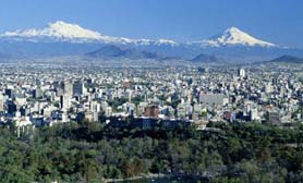
Mexico City is located in the Valley of Mexico, frequently called the Basin of Mexico. The valley is located in the Trans-Mexican Volcanic Belt in the high plains of south-central Mexico. It has a minimum altitude of 2,200 meters (7,217 feet) above sea level and is encircled by both mountains and volcanoes that reach peaks of over 5,000 meters. This valley is absent of natural drainage outlet for the waters that flow from the mountainsides, making the city vulnerable to flooding. Some drainage solutions were engineered through the use of canals and tunnels starting in the 17th century. The city was essentially built on what was Lake Texcoco. Much like California, seismic activity is frequent in the Mexico DF vecinty. Lake Texcoco was drained starting from the 17th century and, although none of the lake waters remain, the city rests on the lake bed which is heavily saturated with clay and shingle. As a result, since the start of the 20th century, the city has sunk as much as nine meters in some areas. This sinking is creating problems with runoff and wastewater management, leading to flooding problems, especially during the rainy seasons. The entire lake bed is now paved over and most of the city’s remaining forested areas lie in the southern areas of Milpa Alta, Tlalpan and Xochimilco regions.